Can you use a Garmin Edge for hiking? (full tutorial)
Share on:
Garmin Edge are devices designed to be used as GPS bike computers, therefore only for cycling. But these devices are great: they have a long battery life, they can display a full map, some can even let you plan a route on the go, and they record your data. This is why people generally wonder if they can use it for other types of activities like walking. Is it possible to use a Garmin Edge for hiking?
A Garmin Edge GPS bike computer is not meant to be used for hiking. It filters automatically low-speed GPS drift and struggles to record low-speed movement even with auto-pause off. The map tracking is correct, but the distance displayed and recorded won’t be accurate.
In this article, I will detail the limitations of using a Garmin Edge bike computer for hiking. I will also describe additional means of recording a hike.
Why is the Garmin Edge not best for hiking?
Garmin Edge bike computers have some limitations for hiking. The software is tuned in for cycling and does not handle well low speeds and arm movements. Therefore it struggles to calculate the walking distance. Garmin edge computers do not integrate a “walking/hiking” profile.
Garmin didn’t add all the features from their outdoors walking GPS devices and multi-activity watches into the bike computers. It is meant solely for cycling. Indeed, Garmin Edge models record data with a “smart” interval, which is a dynamic range computed by Garmin software.
If you compare the number of points recorded with your Garmin Edge and with a specific walking GPS computer, you will notice it’s only recording about half the points. This is the main reason the distance is incorrect when walking.
Many people find that using a Garmin Edge without fiddling with the settings will give you a 25% reduction over the distance recorded. There is a solution to improve the accuracy of the device. I will mention it a bit later in this article.
Is this true for all Garmin Edge models?
Not all Garmin Edge models are made equal. In the past models like Garmin Edge 500, 800, and 1000 all included a walking mode. This was about 10 years ago. This feature no longer exists in most recent models like Garmin Edge 510, 520, 530, 810, 820, 830, 1010, 1020, 1030…
Garmin sells specific walking GPS called outdoors GPS computers, which are meant for hiking.

What to do if you wish to use your Garmin Edge for hiking?
We have seen that Garmin Edge software is limiting the device and as such does not provide accurate recordings when walking/hiking. But the mapping still works flawlessly. It means that if you use your Garmin Edge without changing the settings you will see a distance quite wrong but the GPS track recorded is correct. So if you import this track into Garmin app, you can recompute the distance to the accurate value. But this is not practical and it will export incorrectly the distance to your Strava account.
So if you decide to use your Garmin Edge for hiking, this is what I recommend you do.
Steps to use your Garmin Edge for hiking:
- Create a new activity profile:
Settings -> Activity profile -> Add -> Enter name for the profile - Select “Mountain” in Default Ride Type
- Turn off “Auto Lap” and “Auto Pause” in Auto Features
- Select “Manual” in Timer Start Mode
- Then go back to the main menu
- Select Settings -> System -> Data Recording
- Change the Recording Interval to “every 1 second“
- Keep your device in your hand or outside your backpack to help the GPS connection
By doing all the steps above, you have put the best chances to increase the accuracy of your device. Auto Pause is a feature that struggles at low speed and generally pick-up speeds above 10km/h. So perfect for riding, not for walking. The recording interval will help increase the number of points to record the distance correctly.
Now, consider using Open Street Maps rather than Garmin default map to get more details when hiking.
How to add Open Street Maps onto your Garmin Edge?
1. Go to http://garmin.openstreetmap.nl
2. Select routable bicycle in map type
3. Select a country or state under Predefined country
For instance in the example below, I have selected “Texas”:
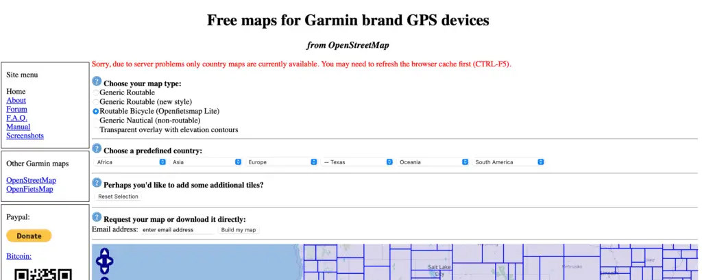
4. On the left column (after the map), download the tiles you want
In the case of Texas, there is a long list of tiles most of the time categorized by cities.

5. You should now have “.img” files for each tile downloaded
6. Connect your Garmin Edge device to your laptop (with the USB wire)
7. Copy the “.img” files onto your Garmin device into the Garmin folder
8. Safely eject the device from your computer
Now your maps are onto your Edge unit.
If you want to check it out, just turn on your Garmin Edge, click on your ‘road’ profile for instance. Then pull down and select ‘user profile’. Then go to Navigation > Map > Map Information and make sure your new maps are enabled in the list.
What device can you use for tracking your hikes?
There are specific devices available on the market to track your hikes with full map support, plenty of battery, and accurate data. Garmin Edge devices are dedicated to cycling which is why there are not the best in this category.
Garmin sells specific GPS computers for hiking, such as Garmin eTrex® 22x, Garmin GPSMAP 66i, Garmin Montana 700i… Some of these devices can be quite expensive.
If you are a cyclist who does hiking from time to time and already own a Garmin Edge device, I recommend trying the steps I mentioned earlier on your Garmin Edge and see if that’s good enough for your need.
Else a good solution is to buy a multisport watch which allows you to use it when riding and when running. Some models include mapping but I admit it is much smaller than on handheld units. I own a Garmin Forerunner 745 which is perfect for my occasional hikes. But you can look at different models like Fenix watches or Forerunner 945 which have longer battery life and better mapping options.
Share on:


