Zwift routes planning: hard? short? flat? (we got you!)
Share on:
>> Article updated to include Scotland routes! <<
Wondering where to ride in Zwift, this is a guide to help you choose a route for cycling. Whether you wonder which route is the flattest, the shortest, the longest… or which climb is harder… I will give you all the details to help you pick the best ride + a very nice printable infographic (for free!).
But first, let me give you a short explanation about Zwift routes and maps. A “route” in Zwift is an official course with a start and finish within the game. Most of these routes will allow you to obtain a badge upon completion, and some will only be available via events. But it doesn’t mean you have to ride these routes.
Indeed, Zwift includes several “worlds”, meaning different maps on which you can ride. You then select a route to start riding into the map of your choice, but once in the game, you can just ride as far as you want. You can control your rider at each turning point to decide which direction you want to go and therefore you don’t need to follow the official route.
Does Zwift have real World routes?
Zwift has several real-world routes where gradient, turns, and distances are represented accurately, with a virtual world appearance. You will find the famous climbs of Alpe d’Huez and Mont Ventoux (France), as well as representations of London, Paris… and some UCI Worlds Championships circuits.
Real-world routes in Zwift will look like the rest of the environment, meaning a virtual world. It’s not going to be identic in look to the real route but it will be accurate in terms of feeling (gradient, shape of the road, and distance).
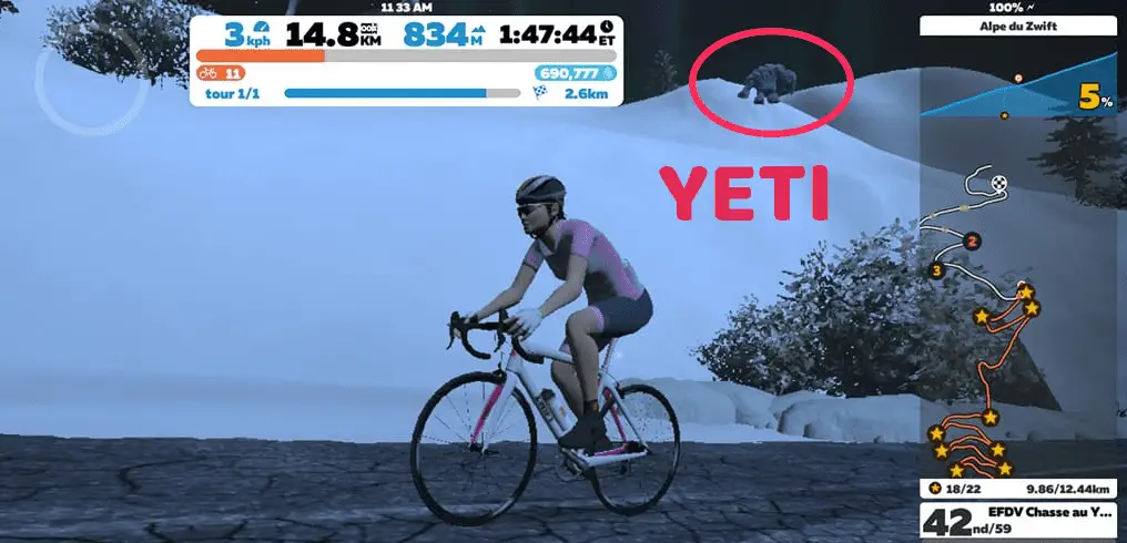
In terms of look, Zwift is creative. In the Champs Elysees replication in Paris, it’s 100% paved road, while the route they chose to represent is actually only 80% paved. For the climbs, the landscape is a bit different but some typical landmarks can be present like the radio tower at the top of Ven-Top (= Mont Ventoux). For Alpe d’Huez (Alpe du Zwift in the game), you can see a Yeti when climbing if you are lucky enough 😉 and snow appears when you climb.
How many routes does Zwift have?
There are 175 routes available on Zwift for cycling, out of which 52 routes can only be accessed through an event. You can get a badge for most of the routes but not all.
If you want to know more about Zwift badges and how to get them, I wrote a dedicated article that you can find here:
The complete list of Zwift badges and how to get them
In the rest of this article, I will focus on Zwift routes that are not ‘event only’ to give you stats about the easiest, flattest, longest, hardest, and shortest routes. Event-only routes can’t be joined at any time, and can be very short and flat to be done as part of specific race events, with several loops of them required. It would not make sense to consider them in the rest of this article.
What is the flattest route on Zwift?
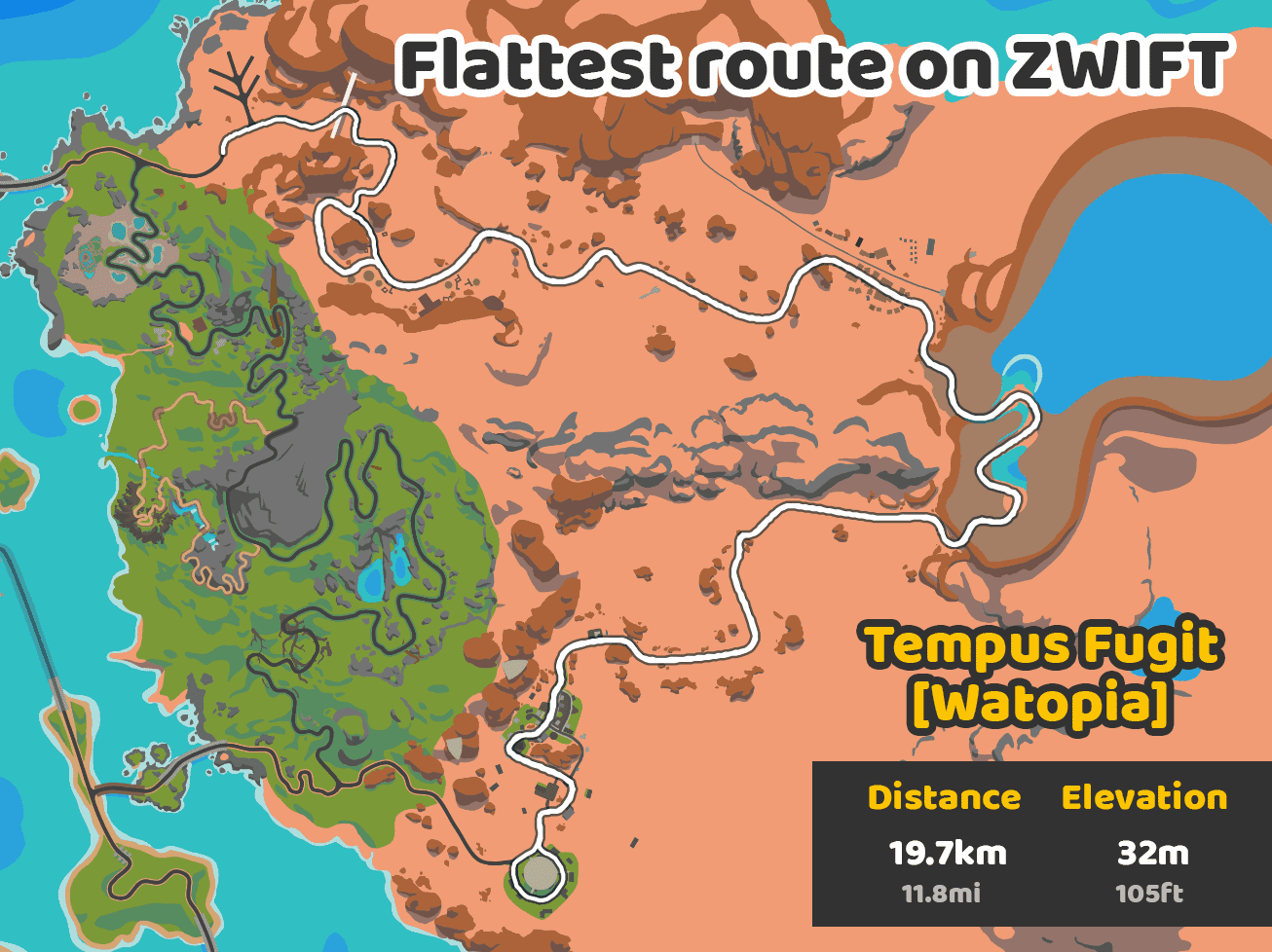
Zwift flattest route is Tempus Fugit from the world of Watopia. It’s 17km (10.6mi) long with only 16m (52ft) of elevation. If you include the lead-in distance and elevation, you have a total of 19.7km (12.2mi) for 22m (72ft) of elevation. That’s an average of 0.1% incline over the length of the route. It’s definitely very flat!
What is the longest route on Zwift?
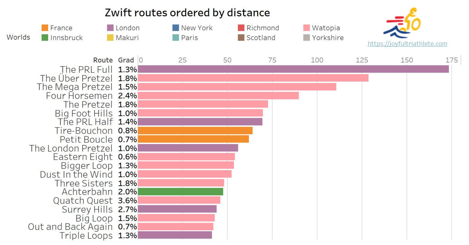
Zwift longest route is ‘The PRL Full’ in London. It is 173.5km long (107.5mi) with 2294m (7526ft) of elevation. It consists in doing 11 laps of the London Loop.
What is the shortest route on Zwift?
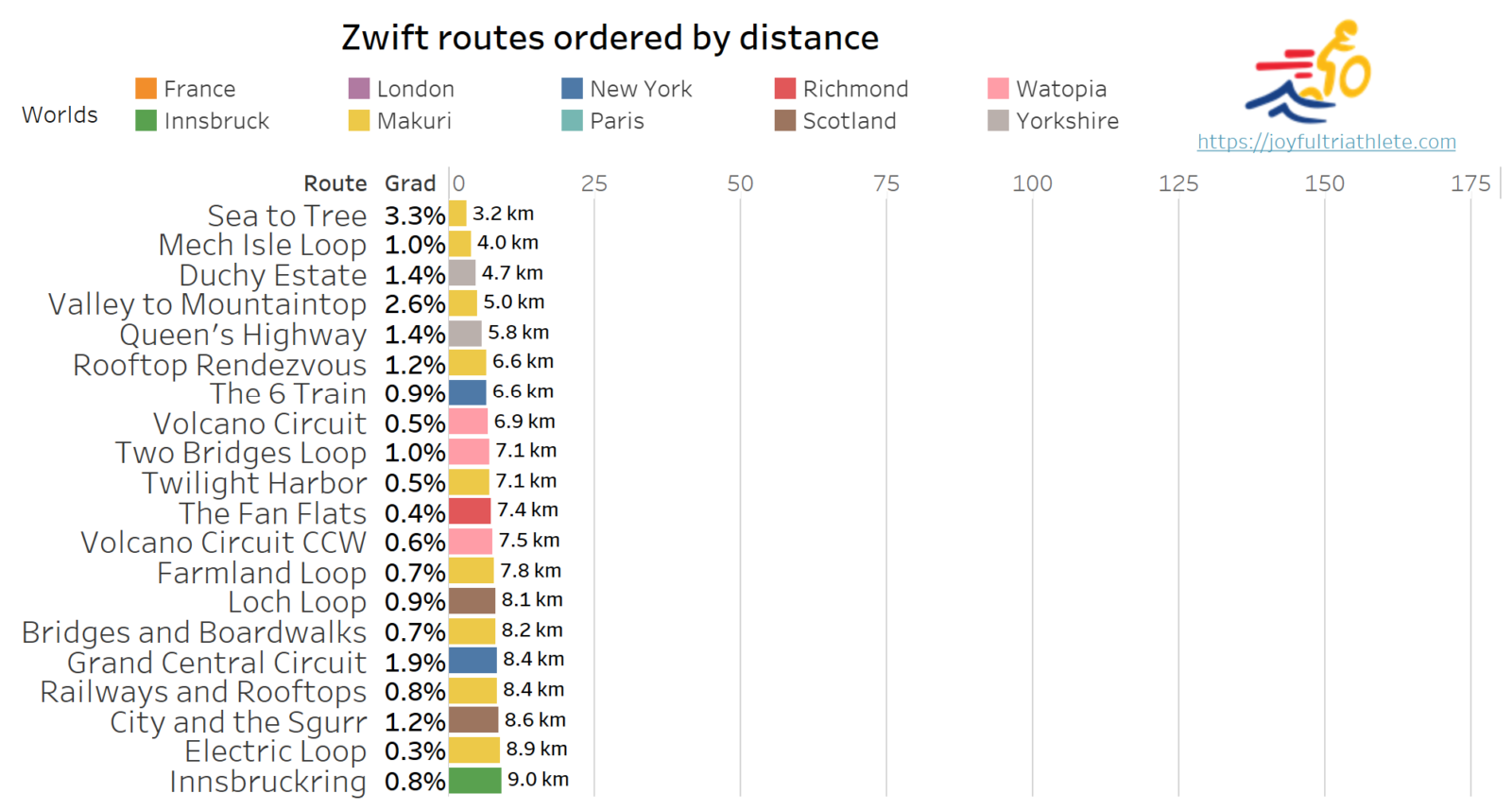
The shortest route on Zwift is ‘Sea to Tree’ in Makuri Islands with only 3.2km (1.9mi) to ride. But you need to climb 107m (351ft). If time is the criterion, ‘Mech Isle Loop’ is faster to ride due to less elevation.
What is the hardest route on Zwift?
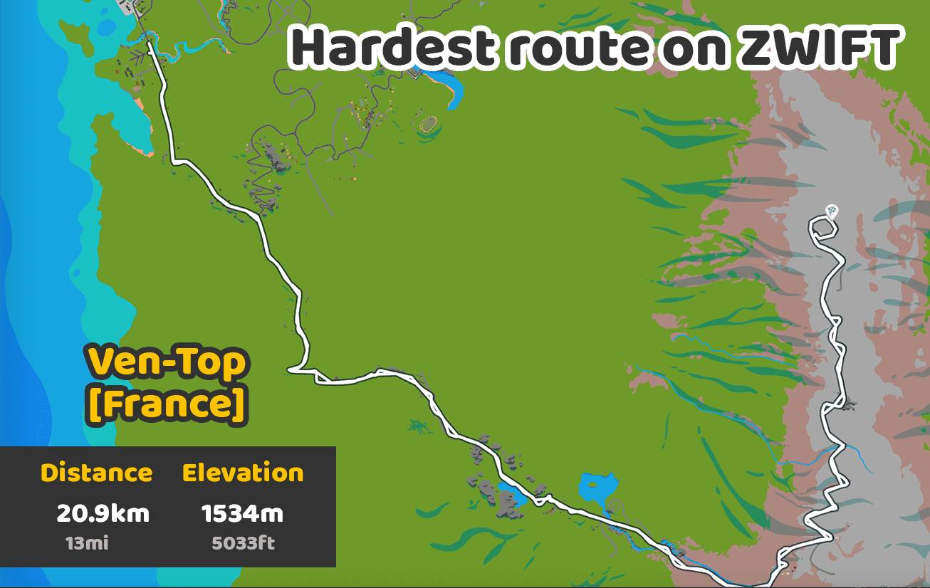
The hardest route is ‘Ven-Top’ in France because it’s a 20.9km (12.4mi) with an average of 7.3% incline. It’s the iconic climb from Mont Ventoux from Bedoin’s side.
What is the easiest route on Zwift?
The easiest route on Zwift is ‘Tempus Fugit’ in Watopia as it is almost perfectly flat. However, you can find shorter routes than this one which are very easy: ‘Electric Loop’ in Makuri Islands is only 8.9km (5mi) with 29m (95ft) of climbing for instance.
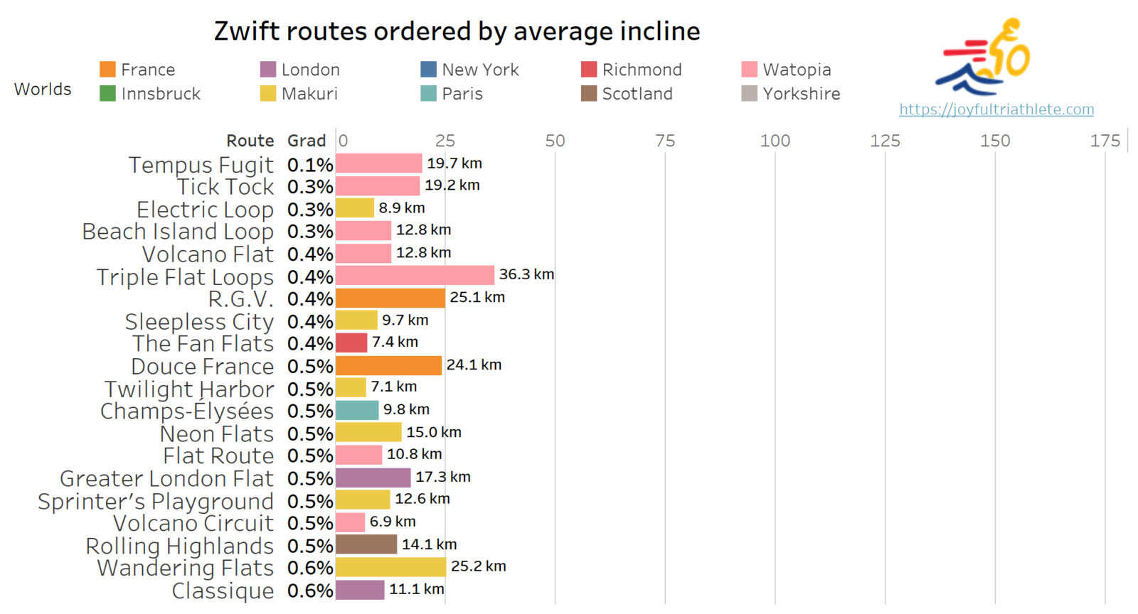
Please see below the list of Zwift easiest routes based on the average gradient of the route. They are ordered by ascending gradient:
Infographic: Zwift routes by difficulty
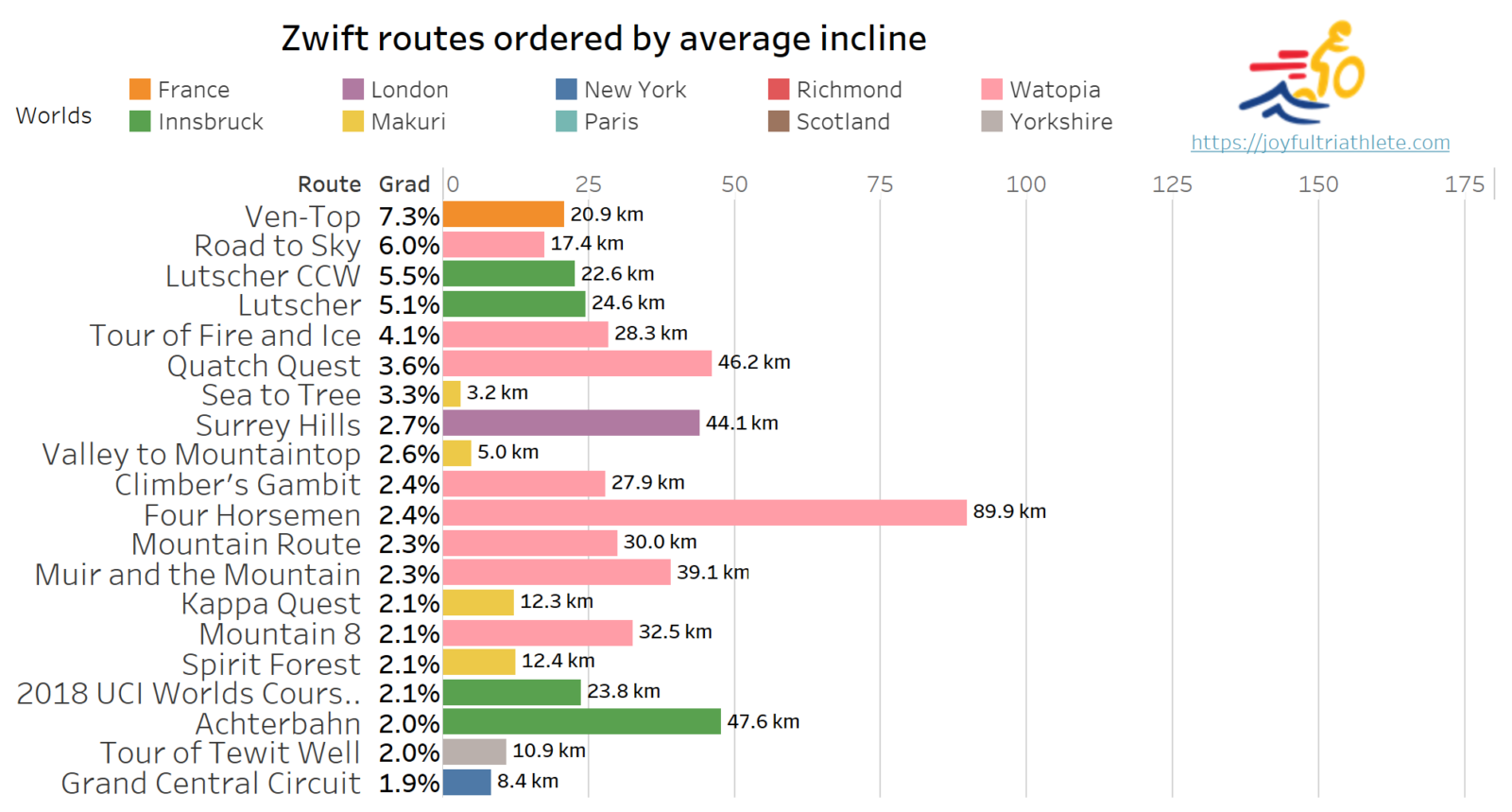
Please find below an infographic I have created to help you plan your next Zwift route. It shows both distance and gradient with routes sorted by average incline. The color code also shows you in which world the route is available.
It lists all the routes available in Zwift, events excluded. It’s perfect if you are looking to train by increasing the difficulty of your rides smoothly. Click on the image to have the complete list as a full-size pdf.
The vertical lines spaced evenly each 25km are here to help you select routes in a certain range of distances.
Which is harder Alpe du Zwift or Ven-top?
In Zwift, Ven-Top route is harder than Alpe du Zwift because the climb is almost 9km (5.6mi) longer with only 1% reduction in average gradient. In particular, it takes on average 30 min more to climb Ven-Top. Looking at the profile, you will have higher slopes on specific segments in Ven-Top.
| Climb | Distance | Gradient |
|---|---|---|
| Alpe du Zwift | 12.2km (7.5mi) | 8.5% |
| Ven-Top | 20.9km (12.4mi) | 7.3% |
If we look in detail at Alpe du Zwift, you can see that the gradient is tough at the beginning and then “eases off” a bit for the rest of the climb. You will start climbing with up to 9 and 10% incline in the first two kilometers, then you will remain at around 7-8% for the next 4km. You will then face another 2km of 9% before 1km of lovely 6%. The remaining kilometers of climbing will be at around 9%.
So Alpe du Zwift is “quick” but tough. It’s steep and not much time to relax, as you can see in the graph above. Feel free to click on the ‘2D’ option to better visualize the maximum gradient per kilometer.
Note: to ride Alpe du Zwift, you can’t directly start at the bottom like Ven-Top. You will have to select Road to Sky which adds 5km of a slight downhill ride at the beginning.
In comparison, Ven-Top is very different. It’s much longer than Alpe du Zwift but starts with an easy gradient in the first 5km with 3 to 5% incline. Nice and easy 🙂 Then that’s when it becomes really tough: 9km of 8 to 10% average. Meaning you will get to see up to 12% in short areas.
Luckily it will ease off a bit afterward with 6% incline for the next 4km. The last 3km of the climb will get harder again. Another bit of 8% with up to 11% near the end. Overall, it’s a long climb, but 1/3 of the climb is relatively easy (less than 7%) while the rest is harder than Alpe du Zwift. This is why Ven-Top is harder than Alpe du Zwift.
Can you create a route on Zwift?
No you can’t create a new route on Zwift. However, you don’t have to ride a specific route in Zwift. You can pick a world and freely ride in it wherever you feel like going, like in real life.
For instance, if you decide to ride in Watopia. Imagine you select ‘Flat route’ to start with. Zwift will automatically let you ride the white loop highlighted in the picture below. But using Zwift companion app, you can decide to turn left at the first junction for instance and start following the orange path. At each junction in the game, you can choose the direction you wish to follow. The better you know the map, the easier it will get to avoid climbs ;).
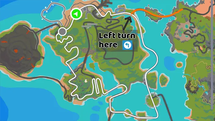
Unfortunately, it is not possible to create a custom route so that your avatar takes the turns at each junction automatically. Thus you can’t create a custom path that you plan to take regularly for your training routine for instance. You will need to manually turn each time.
If you enjoyed this article about Zwift routes, do not hesitate to look at my other guides about Zwift badges or Zwift training plans:
The complete list of Zwift badges and how to get them
How Zwift training plans work (duration, type, cost)
Share on:





I came across your article and saw the comment that it’s not possible to create a custom route for Zwift.
That’s something I always wanted to have… so I built RoadCaptain!
With RoadCaptain you can build your own routes in Watopia, Makuri Islands and France.
Head over to https://roadcaptain.nl to download it
Thanks!