Using a Garmin Forerunner for hiking (possibilities & tips)
Share on:
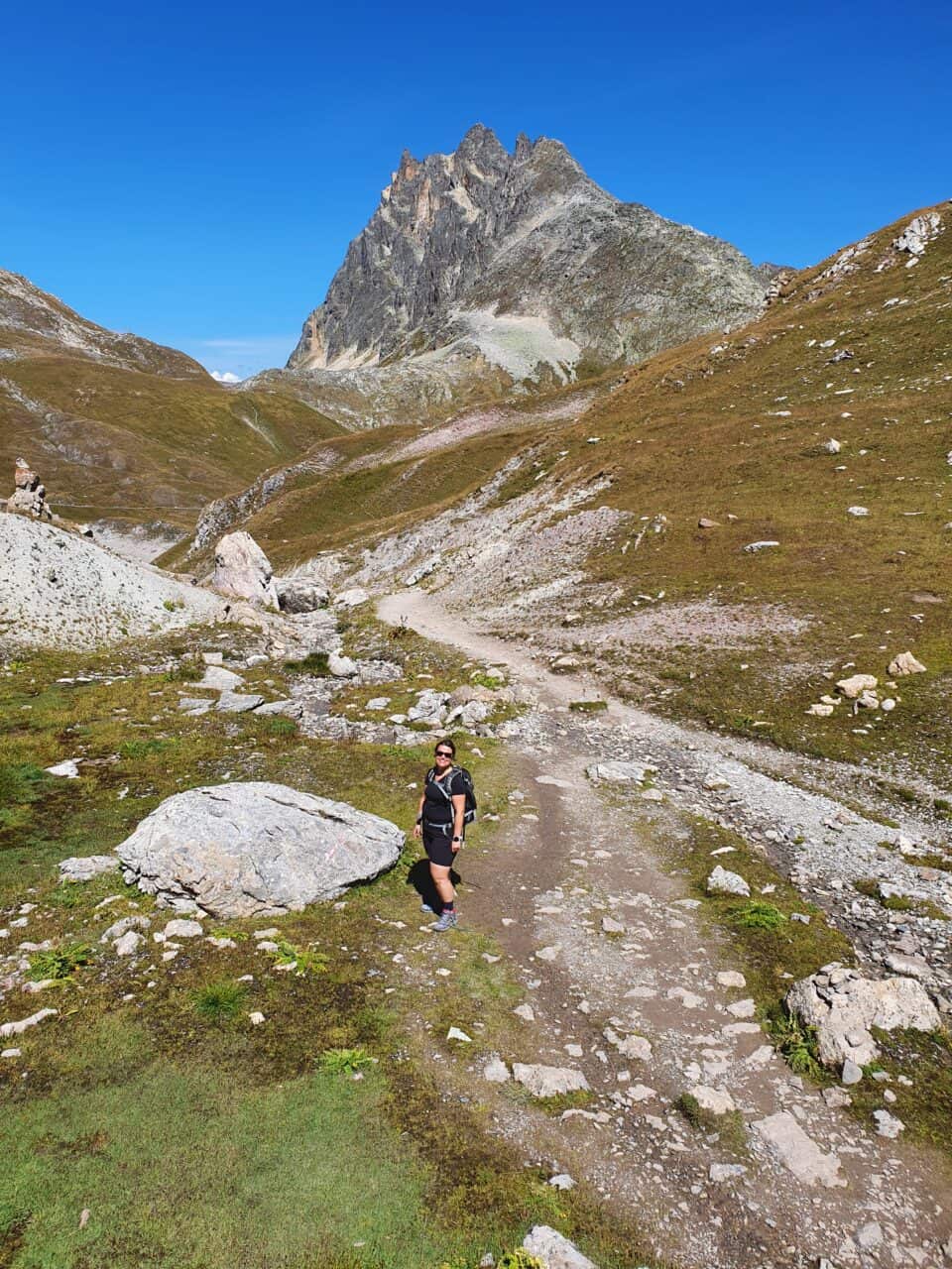
I went Hiking this summer with my Garmin Forerunner 745 and really enjoyed being able to pre-load a trace to follow in the mountains. I had never thought of using any of my previous Garmin Forerunner watches to hike and it made me wonder which Garmin Forerunner watches can be used for hiking.
If you already own a Garmin Forerunner watch for your everyday sports activities, it is likely that you can benefit from it to record your hikes. Depending on the model, you might be able to enjoy features very useful when hiking. I will cover these features in this article.
If you own a Garmin Edge bike GPS and want to use it for hiking, find the full guide here.
Can you use Garmin Forerunner for hiking?
Garmin high-end models, such as Garmin Forerunner 255, 745, or 955, can be used for hiking. They have altimeters, a long battery life, and a trace or map mode. Entry-level Garmins, like the Forerunner 55 or 235 are less suited for hiking because they lack these functions.
Garmin also sells dedicated watches intended for adventure and generally better for several days of hiking like Tactix, Enduro and Instinct watches. You might want to check them out as well.
However, you can use any GPS watch to record a hike.
It’s essential to have a good watch if you go to the mountains and want to rely only on the watch for mapping and altitude. But if you only care about recording your Sunday walks, you probably don’t need much more than a basic GPS watch to record distance and trace. That’s enough for showing your friends what you did, and/or checking out your steps and calories. In this case, any Garmin Forerunner watch will do the job.
Key parameters for choosing a watch for hiking:
- GPS function (obviously :))
- Good battery life (ideally more than 10h with GPS)
- Detailed Map or at least GPS trace
- Barometric altimeter (for accurate elevation and find out when a storm is coming)
- Compass
- Hiking / Walking mode (to record data in the correct metric)
Comparison of Garmin Forerunner watches for hiking
Based on the key parameters mentioned before, I have prepared a comparative table of all Garmin Forerunner watches.
In the table, I used a specific color scheme per category of watch. For instance, in blue you have the low-end watches of the Forerunner series, in green the watches focused on running, in grey the ones focused on triathlon…
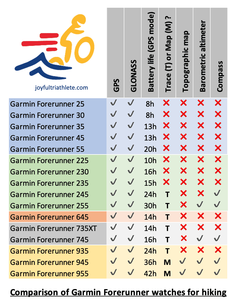
In each group, the recent models are the ones with the highest number in the model name.
As you can see, all these watches have GPS & GLONASS to allow you to connect to satellites to get the distance and elevation. Only a few have a barometric altimeter but it looks like the newest watches will get it by default in the future, except for the low-end series. But the mapping capability is quite rare. Recent models tend to take on board the ability to have a trace to navigate with, except for low-end watches. Only two models have a proper mapping system: Garmin Forerunner 945 and 955.
To summarize, if we look at the recent models of Garmin Forerunner only:
- Garmin Forerunner 55 will allow you to record your activity and then view the trace, distance, and elevation after the activity is finished. But it won’t help you navigate while hiking. This is not an issue if you carry your phone with a loaded map on it.
- Garmin 255 & Garmin 745 will allow you to record your activity with more precision than Garmin Forerunner 55 due to the barometric altimeter. Elevation will be more accurate but that’s not essential for everyone. These two watches have the ability to load a trace to help you navigate around. It’s not always easy to use without taking the wrong paths from time to time but it’s a good help.
- Garmin Forerunner 955 is an expensive watch but with all the features you need if you hike regularly. There is even a solar model that will give you extra battery by charging using the sunlight. This watch is an upgrade to Garmin 745 with a full mapping system.
Which Garmin Forerunner watches have maps?
Garmin Forerunner 945 and 955 have detailed maps. While Garmin Forerunner 935, 745, 735XT, 255 and 245 only show a trace. All the other Garmin Forerunner watches do not have the ability to map a route.
The trend we can notice is that Garmin is adding ‘trace’ ability to their recent models, except for the low-end watches. And the mapping ability is only for the higher-end watches.
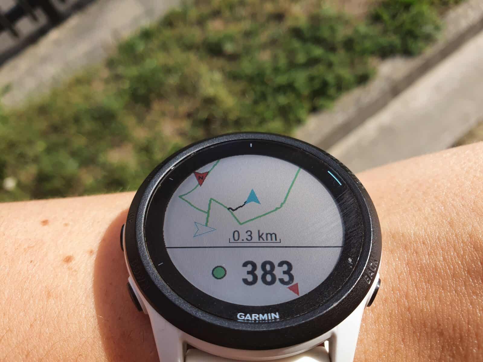
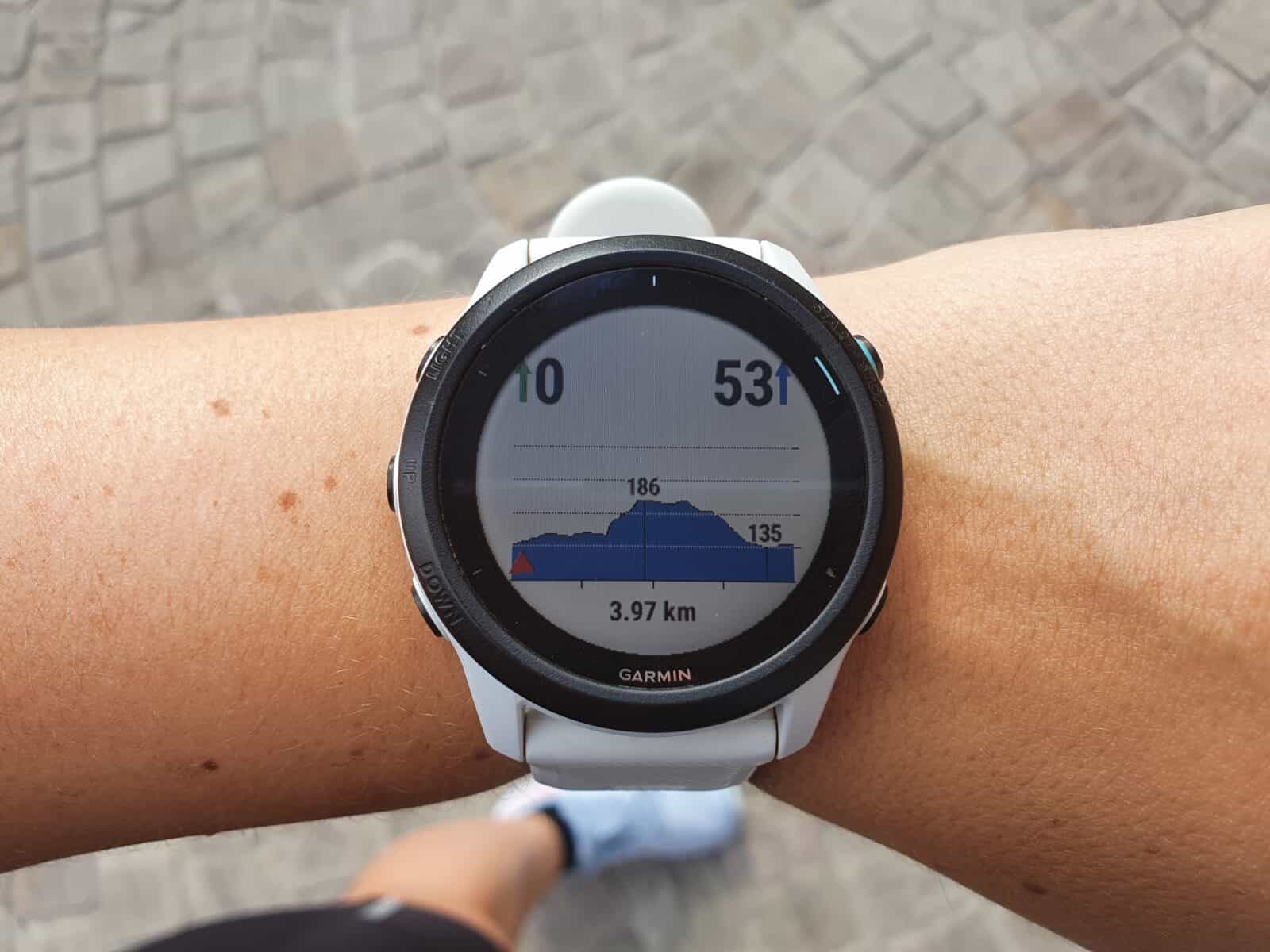
Having navigation on your watch (map or trace) will also give you access to the elevation profile of the course, as you can see in the picture below.
Difference between trace and map
A ‘trace’ is just a line on the screen showing the direction you need to go. It will help you by giving general directions and the remaining meters before the next turn. You won’t see the details of the roads as a map but general directions with a line and turn-by-turn instructions.
If you have the map option on your watch, you will see underneath the trace a detailed background, which includes streets and topography. So, when you reach an intersection you will be able to see on the map a view of all the streets at the junction, and the trace going through one of them. Like when you use ‘google maps’ for instance.
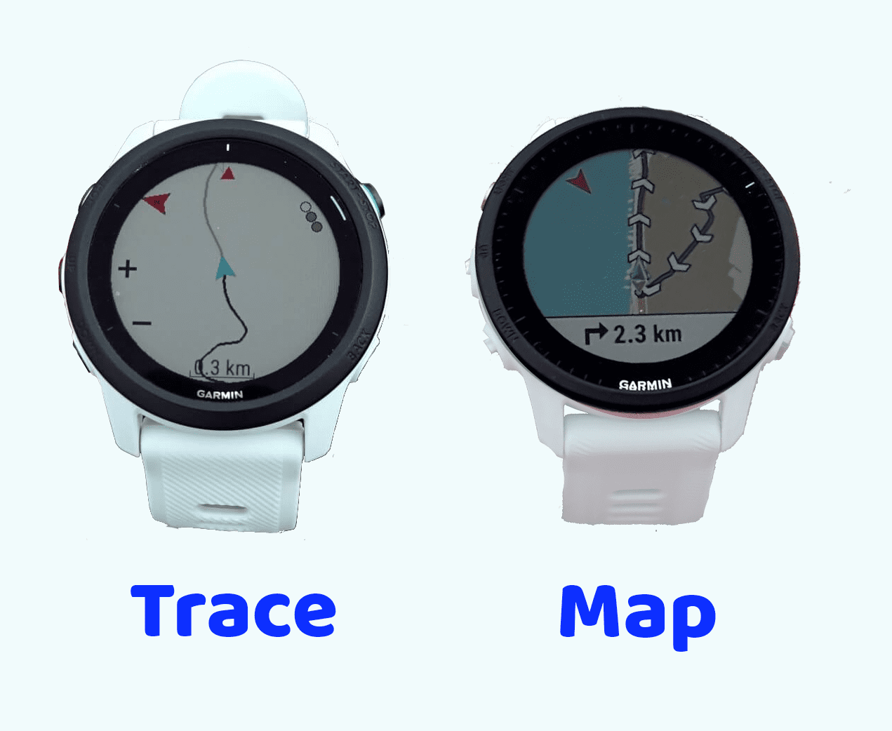
Watches with a mapping system will allow you to download different background maps more or less detailed depending on what you want to see.
How do you get directions on your Garmin Watch?
There are different ways to get directions on your Garmin watch.
- A. The most common one is to prepare a course beforehand and load it on your watch when you go out. This will give you turn-by-turn directions to follow.
- B. Another way is to select an activity done previously and get directions to redo the same path.
- C. Navigate to saved locations
- D. Use the watch to create a course based on distance and direction
For hiking, the most relevant methods are A and B. But methods C and D are still helpful and interesting to know, that’s why I am going to cover them.
A. Create a course with Garmin Connect & send it to your watch
One option to get direction on your Garmin Watch is to prepare a course to navigate with Garmin Connect and then export it to your watch. This process works for all watches that can display at least a trace (please refer to the table presented earlier for the detailed list of Garmin Forerunner watches compatible).
Steps to follow to create a course and export it to your watch:
- Create a course on https://connect.garmin.com/modern/courses or on the app under training > courses > create Course
- Once the course is ready, save it
- Go to Garmin Connect application in training > courses
- Click on the course you wish to upload on your watch
- Click on the vertical dots in the top right corner
- Choose Send to Device
- Select your watch
- The course will upload on the watch next time it gets synced with the app.
You can force it manually on the app if you prefer.
Note: you can create a course on any app of your choice as long as it’s a .gpx or .tcx file. Then upload it on Garmin Connect and export it to the watch in the same way we just did above. For instance, you can use Komoot, Strava, Alltrails… to create the route. You are not limited to using Garmin Connect.
Steps to follow to get directions from a pre-loaded course on your watch:
- Press start on your watch
- Select the activity of your choice (in this case Hike)
- Press the up arrow to reach the options (before recording the activity)
- Select Courses
- Choose the file you uploaded before
- Select Do Course
- Press start to launch the activity
- Press down until you see the screen with the map
B. Load the route from a previous activity
Only watches with navigation ability (trace or map) can do this feature (refer to the table above for the list of watches).
Steps to load a course based on a previous activity performed:
- Press start on your watch
- Select the activity of your choice (in this case Hike)
- Press the up arrow to reach the options (before recording the activity)
- Select Navigation
- Select Activities
- Choose the one you want to repeat
- Select Go
- Press start to launch the activity
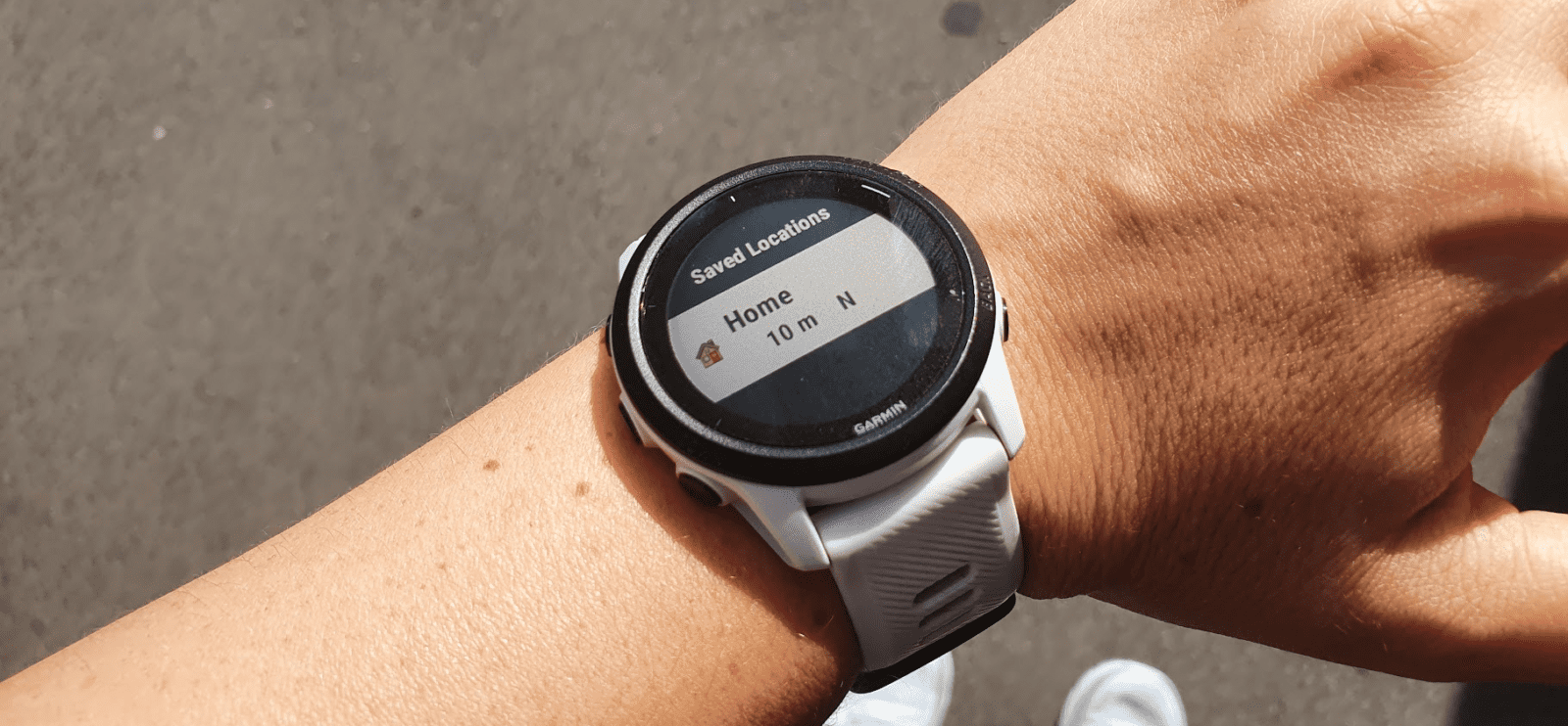
C. Navigate to a saved location
Only watches with navigation ability (trace or map) can do this feature. For this option to work, you need to have saved locations on your watch before. This is why I recommend you do it regularly.
Steps to save a new location in your watch
- Press Light for a couple of seconds until you see a menu appear
- Scroll until you see the Save Location icon
- Wait for GPS if it’s not active (you can’t do it indoors)
- Press Start to Save
- Press Down to edit the name and icon (if you wish)
- Press Back once done
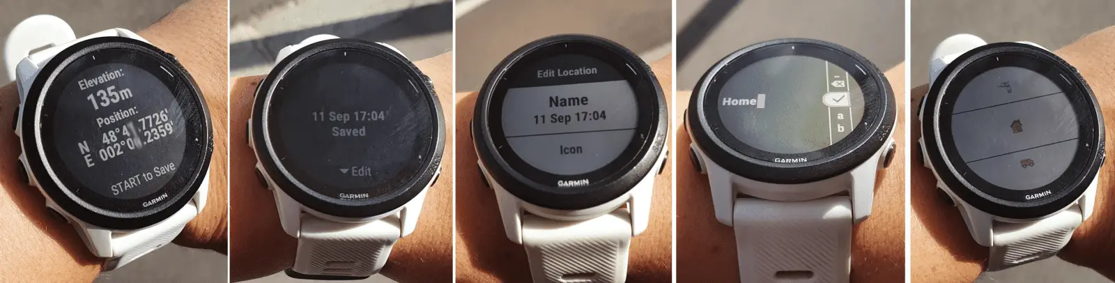
- Press Start to save
With Garmin Forerunner 945 and 955, you can similarly go to a point of interest of your choice, except you don’t need to memorize them all manually by going to a location and saving it. You can load a map that includes points of interest and then search through them.
Steps to navigate to a saved location
- Press start on your watch
- Select the activity of your choice (in this case Hike)
- Press the up arrow to reach the options (before recording the activity)
- Select Navigation
- Select Saved Locations
- Choose the place you want to go to
- Select Go
- Press start to launch the activity
D. Create a course directly on the Watch
This alternative is only possible on Garmin Forerunner 945 and 955.
It will allow you to directly create a route with your watch. This is not a mean to navigate but a way to create a nice trip around your house based on direction and distance. For instance, you wish to do a 5km loop heading South from your current location, the watch will draw 3 options for you to choose from and then direct you to follow it.
Steps to create a new course with the watch:
- Press Start
- Select an activity
- Press the up arrow to reach the options (before recording the activity)
- Select Navigation then Round-Trip Course.
- Enter the total distance for the course.
- Select a direction heading for your route. The watch will generate 3 courses that you can view before selecting one of them.
- Select Start to launch the course of your choice
How to navigate back to the starting point during an activity
Only watches with navigation ability (trace or map) can do this feature (refer to the table above for the list of watches).
Steps to navigate back to the starting point during an activity:
- Start an activity on your watch (no need for this activity to rely on navigation)
- Once you want to head back, press Stop to show the menu
- Scroll down to select Back to Start
- Select TracBack to go back using the same way or select Straight line to head back faster
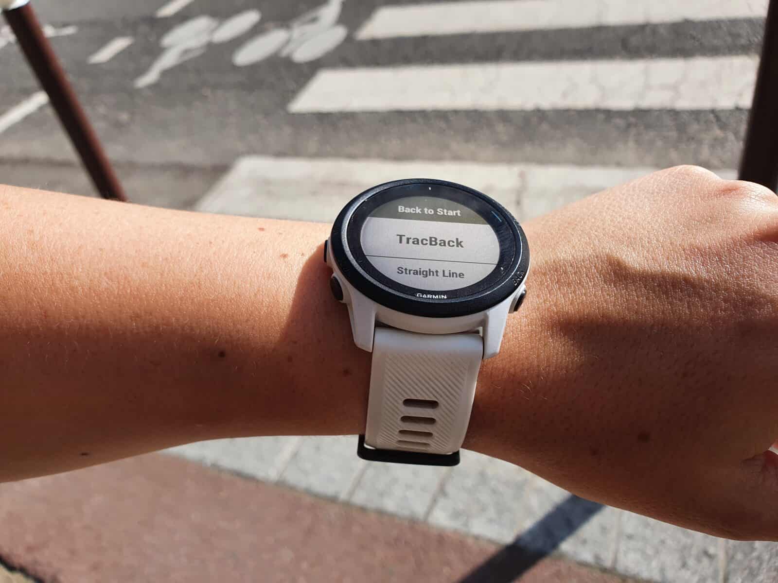
- The map will appear showing you the way back home
On a similar topic, you may like to read this article about hiking with a Garmin edge:
Share on:


Hello, nice report! Are there differences to follón a route between 245 and 255 by the latters barometer? I mean, only following the routes path the most accurately without getting lost..
thanks
Hi Daniel, to follow a route hiking you won’t see a difference between 245 and 255 watches. It’s just the accuracy of the elevation that will be off a bit without the barometer. But it won’t affect the trace because it relies on the GPS.
Elevation can be useful to know how far off you are from the summit for instance, and having a barometric altimeter will allow you to have the elevation profile of the route you want to follow. So you know how much climbing or when it goes up or down. This is not available on the 245.
I cannot thank you enough for this fantastic overview- every question answered and anticipated rather than just recommending the same two affiliated products. Hugely appreciated, thank you!